
What a Boundary Survey Actually Covers and How Much It Costs
If you’re buying land, putting up a fence, or dealing with a disagreement over where your property ends and your neighbor’s begins, a boundary survey is likely the first thing a licensed surveyor will recommend. It’s one of the most common types of surveys ordered by homeowners, and also one of the most misunderstood.
This article breaks down what a boundary survey actually includes, what drives the cost, and when you genuinely need one.
What a Boundary Survey Is
A boundary survey is a field measurement that confirms the legal edges of a parcel of land. A licensed Professional Land Surveyor researches the deed history and public records tied to your property, then goes out to physically locate, verify, or set corner markers based on those records.
The end result is a stamped plat map or survey report that shows your property lines as they legally exist. That document carries legal weight. It’s the kind of record that holds up in a permit application, a real estate closing, and a property dispute.
It’s worth being clear about what a boundary survey is not. It does not assess the condition of a structure. It does not evaluate flood risk. It does not replace a topographic survey if you need elevation data. It has one job: to establish where your property legally begins and ends.
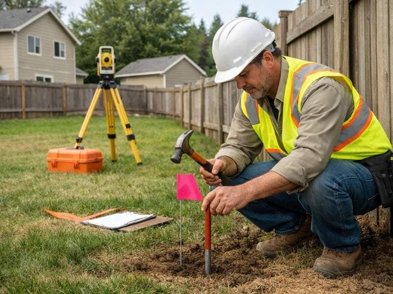
What the Surveyor Actually Does
A boundary survey is not just a site visit. A large portion of the work happens before the surveyor ever arrives at your property.
The process typically follows this order:
- Deed and record research. The surveyor pulls your deed, previous surveys, plat maps, and any recorded easements or boundary line agreements tied to the parcel.
- Neighboring property research. Adjoining parcel records are reviewed to understand how your boundaries relate to the properties around you.
- Field work. The surveyor visits the property to locate existing monuments, iron pins, or corner markers. Where markers are missing or disturbed, new ones are set based on the legal record.
- Calculations and drafting. Measurements are processed and a plat or survey map is produced, reviewed, and stamped by the licensed surveyor.
The field portion can take a few hours on a straightforward residential lot. The research and drafting phases can take just as long, sometimes longer, depending on how far back the records go and how complex the title history is.
How Much a Boundary Survey Costs
Boundary survey costs typically fall between $800 and $3,500 for a standard residential lot. That’s a wide range, and it exists for good reason.
Several factors affect where your quote lands:
- Lot size. Larger parcels take more time to measure and document.
- Terrain. Sloped lots, canyon-adjacent properties, and coastal parcels often require more fieldwork than flat, open land. In San Diego County, the varied terrain, from hillside neighborhoods to coastal bluffs, can add 20 to 40 percent to the base cost compared to a flat suburban lot.
- Record complexity. If your property has older deeds, unclear legal descriptions, or a history of transfers, the research phase takes longer. That time adds to the cost.
- Existing monuments. If corner markers are already in place and in good condition, the fieldwork is faster. If they’re missing or have been disturbed, the surveyor must reconstruct the boundary from other evidence.
- Dispute involvement. If a neighboring property owner contests the boundary, the process becomes more involved and the cost reflects that.
Always get a written quote before work begins. Reputable surveyors will outline what’s included in their fee and what circumstances might change the final price.
When You Actually Need One
Not every situation calls for a boundary survey, but some situations clearly do.
You likely need a boundary survey if you are:
- Buying a vacant lot or rural parcel where lines have never been physically confirmed
- Planning to build a structure, fence, or addition near a property line
- Applying for a building permit or ADU approval, where confirmed setbacks are typically required
- Involved in a dispute with a neighbor over where the shared line sits
- Dividing a parcel or adjusting a lot line
If you’re purchasing an existing home with a recent, clean title history and no planned construction, you may not need one right away. A real estate attorney or title officer can help you assess whether the situation warrants one before closing.
How Long It Takes
In San Diego, most residential boundary surveys are completed within one to three weeks from the time you place the order. Complex properties, older records, or parcels with disputed histories can push that to four to six weeks. If your timeline is tied to a permit application or a closing date, factor this in early.
Frequently Asked Questions
Is a boundary survey the same as a property line survey?
Yes. The two terms are used interchangeably. Both refer to a survey that locates and documents the legal edges of a property.
Does a boundary survey need to be recorded?
In California, a licensed surveyor’s map must be filed with the county when new monuments are set. If your survey only locates existing monuments without setting new ones, recording requirements may differ. Your surveyor will advise you based on the specifics of your property.
Can I use an old survey instead of ordering a new one?
Sometimes. If a survey was done recently, covers the same parcel, and used the same legal description, a new survey may not be necessary. However, if conditions have changed, if construction is planned, or if there is any question about the boundary, a current survey is the safer choice.
Who pays for a boundary survey in a real estate transaction?
This is negotiable between buyer and seller. In practice, the party who needs the information most often pays for it. Buyers frequently order their own survey independently of what the seller provides.
What happens if the survey reveals the fence is in the wrong place?
It depends on how far off the fence is and what your agreement with your neighbor looks like. Some encroachments are resolved informally. Others require a boundary line agreement or, in serious cases, legal action. The survey itself does not resolve the dispute, but it gives both parties a factual, legally grounded starting point.