This site is intended to provide you with information on Land Surveying in the San Diego, CA and San Diego County area of California. If you’re looking for a San Diego Land Surveyor, you’ve come to the right place. If you’d rather talk to someone about your land surveying needs, please call our local number at (619) 762-4447 today. For more information, please continue to read.
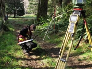
Land Surveyors are professionals who make precise measurements to determine the size and boundaries of a piece of real estate. While this is a simplistic definition, boundary surveying is one of the most common types of surveying related to home and land owners. If you fall into the following categories, please click on the appropriate link for more information on that subject:
San Diego Land Surveying services:
I need to know where my property corners or property lines are. (Boundary Survey)
I have a loan closing or re-finance coming up on my home in a subdivision. (Lot Survey)
I need a map of my property with contour lines to show elevation differences for my architect or engineer. (Topo Survey)
I’ve just been told I’m in a flood zone or I’ve been told I need an elevation certificate in order to obtain flood insurance or prove I don’t need it. (Flood Survey)
I’m purchasing a lot/house in a recorded subdivision. (Lot Survey – See Boundary Survey if you’re not in a subdivision.)
I’m purchasing a larger tract of land, acreage, that hasn’t been subdivided in the past. (Boundary Survey)
Contact San Diego Land Surveying services TODAY at (619) 762-4447.
Owners behind a levee often assume the structure ends the conversation. An Elevation Certificate proves that assumption wrong on a regular basis, because protection and classification are two separate ideas. A levee can lower real flood risk while the land behind it still sits in a mapped zone that triggers requirements. The wall and the map answer different questions, and only one of them shows up in a loan file.
Understanding the Difference Between Protection and Classification
A levee holds water back. A flood map does something else. It assigns a zone to a piece of land based on how the mapping agency reviewed the system and the modeling behind it. The two line up sometimes. Other times they do not, since a levee only changes the mapped zone when it meets the agency’s standards and earns formal approval.
A system that falls short of those standards leaves the ground behind it mapped as though the levee were not there at all. Owners find that confusing, and they have every reason to. The map reflects a technical and legal review. It does not reflect the height of the earth berm someone can see from the back fence, however solid that berm may look.
Identifying the Flood Data Assigned to the Building Location
The certificate records the flood data that applies to one building. The surveyor finds the map panel and its date, the flood zone at the building and the base flood elevation where the map lists one. Those entries come straight off the published map. None of them rest on the surveyor’s opinion.
Picking the right panel matters more than it sounds. Maps get revised. A property near a zone line can sit in one zone on an old panel and a different zone on the current one. The certificate uses the map in effect, and the date on the form tells a reviewer which version the crew worked from.
Measuring the Structure From an Accepted Vertical Reference
Elevations mean nothing without a reference. Every height on the certificate ties back to a published datum through a benchmark, and the form records both. Two surveys of the same house can report different numbers if they start from different datums. That is why the reference always gets written down.
The crew documents that connection so a reviewer can check the work. Naming the benchmark, its published elevation and the datum lets someone else repeat the measurement and land in the same place. That ability to retrace the work is the reason the numbers carry weight at all.
Describing Crawlspaces, Garages, and Low Enclosures
Lower building areas get their own treatment on the form. A crawlspace, an attached garage or a space below the lowest living floor is not simply another floor, and the certificate has fields that classify each one. Flood vents in those walls get counted and measured, since their size affects how the space is evaluated.
Mistakes in this section change the result more than any other error on the form, because they redefine the building itself. The details that need real care include:
the lowest floor, chosen by definition rather than by how the space is used
attached garages, which follow their own rules on the form
crawlspace floors and the height of the ground beside them
the number, size and placement of flood openings in enclosure walls
equipment such as condensers and water heaters sitting on outdoor pads
Calling a garage slab the lowest floor when it belongs in the enclosure fields produces a form that describes a different building. The crew measures what actually stands there and lets the classification follow the construction.
Avoiding Assumptions About Insurance Results
The surveyor measures and records. Everything after that belongs to someone else. Insurance carriers rate policies under their own rules. Lenders apply their own requirements, and floodplain officials enforce local rules that the surveyor does not interpret.
That division of labor protects the owner. A number on a form can be checked, argued and relied on. A prediction cannot.
Owners sometimes want a prediction anyway. A careful surveyor declines to give one. A certificate that promises an outcome damages the only thing it was built to deliver, which is an honest record of how one building sits against published flood data. The measurements hold up in the end because they stay neutral.
Frequently Asked Questions
Does a levee remove my property from a flood zone?
Only when the levee meets the mapping agency’s standards and the maps have been updated to show it. Plenty of systems provide real protection without carrying that status. The land behind them stays mapped the same way it was before the levee existed.
Why does my certificate list a datum?
An elevation means nothing without a stated reference point. The datum tells a reviewer which vertical system the numbers belong to. That allows the building elevations to be compared correctly against the published flood elevation for the site.
Can I use an old certificate from a previous owner?
Sometimes, and it depends on whether the maps, the datum and the building have all stayed the same since the form was signed. A lender or an insurer decides whether an older certificate still works. A remodel, an addition or a map revision usually forces a new one.
FEMA’s Flood Insurance Rate Maps (FIRMs) or just Flood Maps are provided after a flood risk assessment has been completed or updated for a community. This study is known as a Flood Insurance Study. The FIRM gives you the Base Flood Elevations (BFEs) and insurance risk zones in addition to floodplain boundaries. The FIRM may also show a delineation of the regulatory floodway.
Once the “insurance risk zone” (commonly referred to as the flood zone) is determined, actuarial rates, based on these risk zones, are then applied for newly constructed, substantially approved, and substantially damaged buildings. FEMA uses these rates to determine the insurance rate you will pay for flood insurance
FEMA’s Digital Flood Maps
FEMA discontinued the production and distribution of paper flood maps in 2009 as part of its Digital Vision Initiative. This affected all the Flood Maps, boundary information, and study reports. However, clients can still view the products for free through their website or buy them in digital format.
To view these flood maps online, go to FEMA’s Map Service Center and key in your address (hi-lited area shown here) search for your home. This will prompt you to then select the map that covers your area. The Flood Maps are somewhat cumbersome to use online. It is best to go through the tutorial on the bottom right of the address search page for an easier and more effective use of the GIS map.